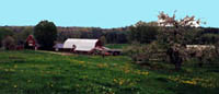
 While only covering a small area, every aspect of New Hampshires geography
is both extremely varied and beautiful. Its topography consists of
a low rolling coast followed by countless hills and its famous mountains
rising out of a central plateau. Its physical features are a result
of the glacial age when the Wisconsin ice sheet moved across New England
from the northwest to the southeast. The climate changes drastically
along with the season.
While only covering a small area, every aspect of New Hampshires geography
is both extremely varied and beautiful. Its topography consists of
a low rolling coast followed by countless hills and its famous mountains
rising out of a central plateau. Its physical features are a result
of the glacial age when the Wisconsin ice sheet moved across New England
from the northwest to the southeast. The climate changes drastically
along with the season.
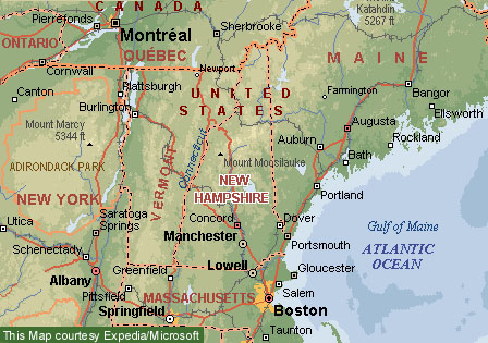
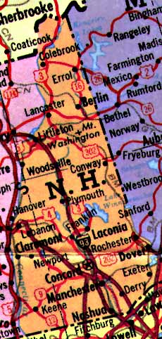
 New Hampshire is one of the six New England states in the northeast region
of the United States. It is bordered on the north by Canada and south
by Massachusetts. ON its western border lies the Connecticut River
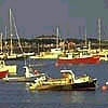
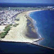
and Vermont on the rivers opposite shore. To the east of New Hampshire
is Maine to the north and the Atlantic Ocean forming the almost eighteen
mile coastline on the southeast side.
New Hampshire is one of the six New England states in the northeast region
of the United States. It is bordered on the north by Canada and south
by Massachusetts. ON its western border lies the Connecticut River
and Vermont on the rivers opposite shore. To the east of New Hampshire
is Maine to the north and the Atlantic Ocean forming the almost eighteen
mile coastline on the southeast side.
The state makes up 9,304
square miles, of which 8,969 square miles are land. It is 180 miles
from the Massachusetts border to its northernmost point. The width
of its southern border, 93 miles, is the greatest anywhere in the state;
the northern border is the narrowest portion, only 19 miles across.
Among the United States, New Hampshire is ranked forty-fourth in size.
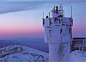
  Characteristic of New England states, the climate of New Hampshire changes
greatly throughout the year. Summers are short and relatively cool,
while winters are long and cold. The White Mountains are the site
some of the harshest winters in the eastern U.S. Temperatures usually
run several degrees cooler in the northern highlands than in the south.
Average monthly temperatures for January range from 10 degrees F up north
to 21 degrees F in the south. Mean temperatures in July range from
61 degrees F to 70 degrees F. Average annual precipitation ranges
from 36 to 42 inches, depending on the area, and reaches an average
of 76 inches atop Mount Washington. Most precipitation in the state
is snow.
Characteristic of New England states, the climate of New Hampshire changes
greatly throughout the year. Summers are short and relatively cool,
while winters are long and cold. The White Mountains are the site
some of the harshest winters in the eastern U.S. Temperatures usually
run several degrees cooler in the northern highlands than in the south.
Average monthly temperatures for January range from 10 degrees F up north
to 21 degrees F in the south. Mean temperatures in July range from
61 degrees F to 70 degrees F. Average annual precipitation ranges
from 36 to 42 inches, depending on the area, and reaches an average
of 76 inches atop Mount Washington. Most precipitation in the state
is snow.
 Over 80%, or approximately 4,981,000 acres, of New Hampshire is forested.
The state is covered with mixed hardwoods and evergreens, most noticeably
maples and birches. The white birch, the official state tree, is
found throughout the state. There are hundreds of species of wildflowers.
Most wildlife is found in minimally populated areas. Common wild
animals include the white-tailed deer, black bear, moose, beaver, skunk,
porcupine, fox, muskrat, mink, otter, raccoon, woodchuck, squirrel, chipmunk,
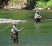
fisher, bobcat, and snowshoe hare. The lakes and ponds are stocked
each year with trout and salmon by the state, but naturally contain perch,
pike, pickerel, trout, horned pout, and bass. More than 300 species
of birds have been sited throughout the state.
Over 80%, or approximately 4,981,000 acres, of New Hampshire is forested.
The state is covered with mixed hardwoods and evergreens, most noticeably
maples and birches. The white birch, the official state tree, is
found throughout the state. There are hundreds of species of wildflowers.
Most wildlife is found in minimally populated areas. Common wild
animals include the white-tailed deer, black bear, moose, beaver, skunk,
porcupine, fox, muskrat, mink, otter, raccoon, woodchuck, squirrel, chipmunk,
fisher, bobcat, and snowshoe hare. The lakes and ponds are stocked
each year with trout and salmon by the state, but naturally contain perch,
pike, pickerel, trout, horned pout, and bass. More than 300 species
of birds have been sited throughout the state.
New Hampshires chief
resource is its scenery and the recreational and tourism income that comes
from it. Its timber resources provide building materials, pulpwood,
and firewood. The state contains several limited mineral resources,
especially granite, feldspar, and mica. Some of the agricultural
products, such as apples, strawberries, blueberries, peaches, and maple
serious, are the finest found anywhere.
Possibly the most notable
feature of New Hampshires geography are its mountains. The White
Mountains are found throughout the northern part of the state. Mount
Washington, which is 6,288 feet high, is the largest of the peaks.
Franconia, Presidential, and Carter-Moriah are the three other mountain
ranges in the state. Eight of the mountains are over 5,000 feet high:
Adams, Jefferson, Clay, Madison, Lafayette, Lincoln, and Franklin.
There are eighty-six mountain peaks in the Presidential Range alone.
One of the most famous rock formations is the "Old Man of the Mountain"
on Profile Mountain of the Franconia Range, but its not New Hampshires
only stone formation. One is the "Indian Head" on Mount Pemigewasset
and the other is the "Old Woman of the Notch" which looks down from Eagle
Cliff.

 New Hampshire is often referred to as the "Mother of Rivers". There
are 40,000 miles of rivers and streams within New Hampshire. Five
of the largest streams in New England originate in the states granite
hills. The Connecticut River is the longest, with 110 miles forming
the states western boundary. The Pemigewasset River starts in the
Profile Lake in the Franconia mountains and travels until it flows into
the Winnipesaukee to form the Merrimack.
New Hampshire is often referred to as the "Mother of Rivers". There
are 40,000 miles of rivers and streams within New Hampshire. Five
of the largest streams in New England originate in the states granite
hills. The Connecticut River is the longest, with 110 miles forming
the states western boundary. The Pemigewasset River starts in the
Profile Lake in the Franconia mountains and travels until it flows into
the Winnipesaukee to form the Merrimack.
There are about 290
square miles of water surface in New Hampshire, which is more than 1300
lakes and rivers. The largest lake, Winnepesaukee, covers over 70
square miles, and is up to 300 feet deep. Other large lakes include
the Squam, Winnesquam, Sunapee, Mascoma, Newfound, Umbagog, Moore, and
Massabesic. In addition to the natural lakes, there are four large,
man-made lakes, formed by dams. Two are on both the Merrimack River
and the Connecticut.
|